
By Mélina Mangal
As an author and
school librarian, I love doing research.
I love poking into different sources to hunt for useful facts. One of those sources that I come back to, no
matter the project, is maps.
I collect maps
whenever I travel, as a souvenir, but also as a reference for future work. I picked up such a map when I visited
Plymouth, Massachusetts years ago, which later helped me as I wrote a story
about cranberry bogs.
I use a range of
maps, starting with the basic street map, physical map, and topographical
map. Typically, I search Google, Apple,
or Bing maps online first, getting a general idea of the area, then zooming in
for greater details.
Not only do maps
pinpoint a specific location and geography, they help inform a range of sensory
details. When I hone in on a location, I
can zoom in on both the natural and human-made elements surrounding it.
So much of what
we might find out about a person or a place from secondary sources tends to be
written for adults. But children are
often interested in more basic, day-to-day aspects of lives, like how did this
person get to school? Maps can help
generate useful questions, but also provide the answers. Where was the
school? Was my subject affected by this
factory nearby? Did they hear the mining
trucks on the road? Did they worry about
flooding?
Maps put things
into perspective. Your subject may say
they walked 5 miles each day. Maybe they
did, but maybe that’s exaggerated recollecting.
If you can pinpoint the exact locations, you can verify accuracy by
selecting the walking directions feature. Is your subject’s neighborhood on the
map? Was it called something else in the
past?
Remember that
locations change as well. A school that
was once located in a certain spot, may have relocated, or closed. Factories and mines can be reclaimed by
nature. And, unfortunately, what we’re
more used to: meadows and forests can be plowed over and built upon.
While researching
facts for my picture book biography The Vast Wonder of the World: Biologist
Ernest Everett Just, I wanted to find out more about Charleston, South
Carolina and the surrounding Low Country area of the late 1880s.
Starting with
digital maps helped me get a general sense of the terrain. I was immediately
struck by the abundance of waterways. I’d learned that Ernest Everett Just’s
family had moved back and forth from Charleston to the country, but seeing the
maps opened up more questions for me.
How did his family travel? What
modes of transportation were available to them at that time? Though I didn’t initially think such
questions were directly tied to his life’s work as a scientist, they helped
flesh out more sensory details that rounded out the story of Dr. Just’s
childhood.
Getting my hands
on historic maps really filled in the gaps.
When I traveled to Charleston and was able to look at maps of the 1880s
from the Charleston Public Library’s historical maps collection, it became
clear that during the time period I was researching, the bridges weren’t yet
reconstructed (one had been destroyed by a hurricane). This pointed to the need to travel by
boat. Further research verified that
this was they way many people got around.
This detail helped bring the 1880s to life for me, imagining the sights
and sounds and smells that young Ernest would likely have experienced.
Using the map, I
listed details that the surrounding physical elements could evoke: the rush of
the river, pelicans flapping overhead, oars dipping into water, waves crashing
against the beach, horses clip clopping on cobblestone, humidity hazing the
woods…
By looking very
closely at the historical maps, I was able to locate the area where his family
moved and where Ernest’s mother had opened a school. Though completely
different now, it was an area rich with wildlife and vegetation. Knowing that
he was exposed to so much of the natural world as a child helped inform the
choices I made as I wrote and rewrote the manuscript.
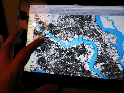
Charleston County GIS map taken by Mélina Mangal
In addition to
maps of specific locales, I like to use sources like the Library of Congress Digital Maps Collection when looking for historical maps. Perusing county maps, and the Historical
Society of the locality you are researching can yield very detailed historical
maps that help you pinpoint specific changes over time. Local libraries often have historical maps in
their collections as well.
Exploring
and free writing with maps provides useful background to inform editing and
specific word choices, but it can also help if you are stuck. Free writing with maps is a springboard for
virtual travel, adding depth and sensory detail to your nonfiction writing, no
matter what stage you are in. Enjoy your
journey!
Give it a Try
Pick a
location from your manuscript, like a home, school, lake, or courthouse. If you
have a physical map, open it up and examine it.
Linger over all place names and physical features. Plot distances your subject might have
frequented.
Do the same with Google Maps or any other map app you may use. Zoom in as close as you can get. Use street view, then aerial view. What’s the terrain like? Zoom out and examine a 2 mile radius. What do you notice? Are there roads? If so, what are they like? Train tracks? Power poles? Any bodies of water?
Generate a list of questions.
Create
a list of physical features like lakes, mountains, train tracks, woods, etc.
Then, imagine what you can see, hear, smell and feel in or near each of these
features, from the perspective of your subject.
Be as detailed as possible. Have fun roaming! With your map, you won’t get lost.
Meet the Author
This is so interesting! What a great way to dive into the setting. Thank you!
ReplyDeleteOh, wow! I never thought about using maps to research. What a great tool, thank you!
ReplyDeleteMélina, thank you for sharing your insight on a topic I haven't thought much about in regards to my writing. I love your biography of Ernest Everett Just, and now I appreciate it even more.
ReplyDeleteEvery journey needs a map!
ReplyDeleteMaps are fascinating! I dove into historic maps of Lower Manhattan for my bio of Henry Bergh, Mercy, and included them in the book. Looking forward to reading your Ernest Everett bio.
ReplyDeleteThank you for sharing this Melina! I love the idea of collecting maps. I've had a story in my head for quite a while that needs to get on paper. Thanks for the nudge:)
ReplyDeleteYes to maps! My husband (a geographer) is fascinated by maps and I used maps I bought for a trip to China for my picture book Two Bicycles in Beijing. I couldn't have written that book properly without the maps. :) Thanks for the resource link for historical maps!
ReplyDeleteThis is so helpful. I also use floor plans of buildings in my wok if I can find them. They are maps of the inside.
ReplyDeleteI'm a nut for all kinds of maps! For me the key of this post is to ask myself questions and see what answers the maps can give me. Thanks, Melina!
ReplyDeleteI love exploring maps! Thanks for the link to the LOC Digital Map Collection.
ReplyDeleteSuch a great reminder. I use maps for much of my research. And not only can you find historic maps online through the Library of Congress, but many historic societies have their local maps digitized. One I found recently was a residence map from c.1900 that indicated what family lived in each house, so I could figure out how close all the relatives were of the MC.
ReplyDeleteI love maps - they contain so much information in such a compact format. I actually used a digital map (and the satellite view feature) to gather details for an interview I was writing when I couldn't travel to the location - then I double-checked with the person I was interviewing. Great list of questions to ask. And thank you for justifying my ever-expanding collection of maps!
ReplyDeleteFascinating post. Thank you! I can see the value in using maps to find out more about a location.
ReplyDeleteWow Melina! You took map resources to a whole new level, thank you!
ReplyDeleteThank you for a very informative post. I now know what a GIS map is and how they are used!
ReplyDeleteMaps! I love maps. I use them for writing and for myself. When I'm planning a trip, the maps come out. I like to know everything about where I'm going. Melina, thank you for this informative post which gives credence to maps and their bird's-eye-view of now and the past.
ReplyDeleteI too love to look at maps, especially while on vacation. Most of my friends don't get it but I like to know how far I've gone and how far I'm going. Can use maps in my stories. Thanks!
ReplyDeleteI appreciate your comments, and the map love! It's great to hear how maps have benefitted your writing as well.
ReplyDeleteSuch a fun exercise! Never thought of doing this.
ReplyDeleteMélina: I never thought of using maps to literally guide me into the world of my characters. What a WONDERFUL way to travel for our characters--as well as we writers in our own little sometimes cloistered worlds (especially during these pandemic times). I CAN'T WAIT to pull out maps to chart my characters' routes to discover their more in-depth stories. THANK YOU for the INSPIRATION to roam on ADVENTURES with our characters!
ReplyDeleteThank you for these excellent ideas! So many holes in one of my current NF WIPs, especially setting-wise, and I think zooming-in map-wise may be a big help! Thanks for sharing this enlightening post!
ReplyDeleteThank you for your great ideas. I'm writing a bio from the 18th C. and I am sure the children will enjoy pouring over the maps of the countryside 10 miles away from the nearest town. Yoiu are an inspirtion!
ReplyDeleteThanks for this fascinating post. I love maps but never considered how they could contribute so much to my writing. Will definitely be using in the future, especially the Library of Congress Digital collection.
ReplyDeleteVery inspiring! Thank you Melina!
ReplyDeleteThank you, Mélina, for sharing the tool of exploring maps to support writing.
ReplyDeleteSuzy Leopold
I'm a big fan of maps and have also found them helpful in my writing, though have used them more to understand time and distance. I love your suggestion to create a list of physical features and then imagine what you can see, hear, smell and feel - will definitely be trying that out! Thanks for the inspiration!
ReplyDeleteThank you, Mélina. Very excellent advice and questions to ask about location. It's not just important in real estate! I'll be looking for your books.
ReplyDeleteWhat a great idea to use maps for researching & verifying information. It is a great way to provide corraboration and sensory detail. Great post, thanks!
ReplyDeleteThis is something I have never thought of before--thank you!
ReplyDeleteMelina, this was wonderful. At first, I thought -- "What about maps will I need?" It did not take me long to realize that you have a lot of important information to share with us. Thank you so much!!
ReplyDeleteSo informative! What a great tool a map can be. Thanks for sharing with us.
ReplyDeleteMaps are so valuable - thanks for this post!
ReplyDeleteThis comment has been removed by the author.
ReplyDeleteWonderful ideas I will apply to both fiction and NF I am working on. Thanks for sharing!
DeleteThank you. I really liked how you allowed the maps to provide sensory details.
ReplyDeleteThank you for this interesting post. I used to pull out and save all the maps from National Geographic magazine. Now I wish I had a map to show where I stored this treasure.
ReplyDeleteAt the huntington.org today i saw an exhibit MAPPING FICTION of the 18th and 19th centuries
ReplyDeleteand now reading your fascinating post, I'm sold on what a great resource maps are.
Thanks for these research tips and inspiration!
ReplyDeleteLove how the maps let you dig deeper into the setting and the story.
ReplyDelete