By Mélina Mangal
As an author and
school librarian, I love doing research.
I love poking into different sources to hunt for useful facts. One of those sources that I come back to, no
matter the project, is maps.
I collect maps
whenever I travel, as a souvenir, but also as a reference for future work. I picked up such a map when I visited
Plymouth, Massachusetts years ago, which later helped me as I wrote a story
about cranberry bogs.
I use a range of
maps, starting with the basic street map, physical map, and topographical
map. Typically, I search Google, Apple,
or Bing maps online first, getting a general idea of the area, then zooming in
for greater details.
Not only do maps
pinpoint a specific location and geography, they help inform a range of sensory
details. When I hone in on a location, I
can zoom in on both the natural and human-made elements surrounding it.
So much of what
we might find out about a person or a place from secondary sources tends to be
written for adults. But children are
often interested in more basic, day-to-day aspects of lives, like how did this
person get to school? Maps can help
generate useful questions, but also provide the answers. Where was the
school? Was my subject affected by this
factory nearby? Did they hear the mining
trucks on the road? Did they worry about
flooding?
Maps put things
into perspective. Your subject may say
they walked 5 miles each day. Maybe they
did, but maybe that’s exaggerated recollecting.
If you can pinpoint the exact locations, you can verify accuracy by
selecting the walking directions feature. Is your subject’s neighborhood on the
map? Was it called something else in the
past?
Remember that
locations change as well. A school that
was once located in a certain spot, may have relocated, or closed. Factories and mines can be reclaimed by
nature. And, unfortunately, what we’re
more used to: meadows and forests can be plowed over and built upon.
While researching
facts for my picture book biography The Vast Wonder of the World: Biologist
Ernest Everett Just, I wanted to find out more about Charleston, South
Carolina and the surrounding Low Country area of the late 1880s.
Starting with
digital maps helped me get a general sense of the terrain. I was immediately
struck by the abundance of waterways. I’d learned that Ernest Everett Just’s
family had moved back and forth from Charleston to the country, but seeing the
maps opened up more questions for me.
How did his family travel? What
modes of transportation were available to them at that time? Though I didn’t initially think such
questions were directly tied to his life’s work as a scientist, they helped
flesh out more sensory details that rounded out the story of Dr. Just’s
childhood.
Getting my hands
on historic maps really filled in the gaps.
When I traveled to Charleston and was able to look at maps of the 1880s
from the Charleston Public Library’s historical maps collection, it became
clear that during the time period I was researching, the bridges weren’t yet
reconstructed (one had been destroyed by a hurricane). This pointed to the need to travel by
boat. Further research verified that
this was they way many people got around.
This detail helped bring the 1880s to life for me, imagining the sights
and sounds and smells that young Ernest would likely have experienced.
Using the map, I
listed details that the surrounding physical elements could evoke: the rush of
the river, pelicans flapping overhead, oars dipping into water, waves crashing
against the beach, horses clip clopping on cobblestone, humidity hazing the
woods…
By looking very
closely at the historical maps, I was able to locate the area where his family
moved and where Ernest’s mother had opened a school. Though completely
different now, it was an area rich with wildlife and vegetation. Knowing that
he was exposed to so much of the natural world as a child helped inform the
choices I made as I wrote and rewrote the manuscript.
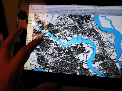
Charleston County GIS map taken by Mélina Mangal
In addition to
maps of specific locales, I like to use sources like the Library of Congress Digital Maps Collection when looking for historical maps. Perusing county maps, and the Historical
Society of the locality you are researching can yield very detailed historical
maps that help you pinpoint specific changes over time. Local libraries often have historical maps in
their collections as well.
Exploring
and free writing with maps provides useful background to inform editing and
specific word choices, but it can also help if you are stuck. Free writing with maps is a springboard for
virtual travel, adding depth and sensory detail to your nonfiction writing, no
matter what stage you are in. Enjoy your
journey!
Give it a Try
Pick a
location from your manuscript, like a home, school, lake, or courthouse. If you
have a physical map, open it up and examine it.
Linger over all place names and physical features. Plot distances your subject might have
frequented.
Do the same with Google Maps or any other map app you may use. Zoom in as close as you can get. Use street view, then aerial view. What’s the terrain like? Zoom out and examine a 2 mile radius. What do you notice? Are there roads? If so, what are they like? Train tracks? Power poles? Any bodies of water?
Generate a list of questions.
Create
a list of physical features like lakes, mountains, train tracks, woods, etc.
Then, imagine what you can see, hear, smell and feel in or near each of these
features, from the perspective of your subject.
Be as detailed as possible. Have fun roaming! With your map, you won’t get lost.
Meet the Author